|
One Program--Innumerable Uses
There are innumerable uses for this powerful application.
We have compiled this list to give you an idea of the versatility of Didger, but the ways
in which you can use Didger go far beyond this list. If you aren’t sure whether
Didger is right for your needs, give us a call and we’ll be happy to discuss the
possibilities with you.
- Geo-reference your raster and vector files for export to
other applications
- Convert your UTM data to Lat/Long or vise versa.
- Create maps from multiple Digital Line Graphs.
- Resample your well log data on specified intervals.
- Digitize oil & gas or monitoring wells
- Digitize soil, rock-chip or other sample locations
- Digitize contours from topo sheets, hand-drawn maps, or
computer-generated maps
- Digitize from aerial or satellite photographs either on
screen or from your tablet
- Reproduce well logs or strip charts even when you don’t
have the original data
- Digitize township and range lines, section lines, or claim
boundaries
- Digitize owner, operator, or property boundaries
- Digitize seismic section lines with shot point locations
- Digitize stream, river, watershed boundaries, lakes and
coastal shorelines
- Map archeological sample sites
- Determine stream length, shoreline length, or watershed or
lake area
- Apply Didger in medical research, such as digitizing
radiation dose calculations from patient films
- Study urban growth such as expansion of residential areas
- Digitize road and street maps and obtain route distances
- Reproduce hand-drawn cross sections
- Digitize wildlife information such as animal habitats,
migratory routes, territorial boundaries
- Digitize geological rock formations, lithologic types, and
faults from maps and aerial photos
- Digitize vegetation boundaries, burn areas, restoration
projects, and lumbering areas
- Determine the area under a curve from a graph
- Digitize meteorological data to produce isobar maps
- Create spreadsheet files for data analysis
- And many other uses
Some of Didger’s Amazing
Features
- Digitize using a digitizing tablet from any map, graph,
aerial photo, site map, or printed image regardless of size using any Wintab32 compatible
digitizing device.
- Use advanced on-screen digitizing of vector or raster plots.
- Import any vector file and retain or apply up to 21 map
projections. Projections supported are: Universal Transverse Mercator (UTM), State Plane
1927, State Plane 1983, Albers Equal Area Conic, Eckert IV and VI, Equidistant
Cylindrical, Gauss-Kruger/Gauss-Conformal, Lambert Azmuthal Equal Area, Lambert Conformal
Conic, Mercator, Miller Cylindrical, Molleweide, Orthographic, Polyconic, Robinson,
Robinson-Sterling, Sinusoidal, Stereographic, Transverse Mercator, and Unprojected
Lat./Long.
- Resample polylines at a specified interval along either the
X or Y axis.
- Use the built-in scanning features to import a bitmap using
any TWAIN compatible scanning device.
- Import vector or raster files using any of the 26 formats
that Didger supports.
- Import data points from 3 different data formats.
- Export vector or raster files using any of the 20 formats
that Didger supports.
- Import and export GeoTIFF images with full support for all
GeoTIFF parameters.
- Specify map datum parameters and perform datum
transformations using the following methods: Molodensky, Bursa-Wolfe, DMA Multiple
Regression Equations (RME), and user defined.
- Convert coordinates to modify the current vector database.
- Specify projection parameters when importing data or vector
files.
- Change the map projection of a project.
- Digitize different cultures on separate layers and export
only selected layers.
- Use Didger data with Surfer®, Grapher™,
MapViewer™, or any other mapping, graphing, or database application.
- Create Surfer BaseMaps and Post maps directly from your
Didger project data.
- Associate four data values or identifiers with each object.
- Use any units (feet, angstroms, miles, meters, kilometers,
etc.) with any combination of linear or logarithmic axes.
- Determine allowable error for your project and work within
acceptable standards based on statistical calibration analyses.
- Obtain length information from polylines.
- Obtain polygon area and perimeter length.
- View and edit data for one object at a time, or view and
edit from a spreadsheet showing all the project data.
- Zoom in or out to display any portion of the project.
- Set project limits for the extent of your project, or let
Didger define default limits.
- Display up to 4 optional labels for each digitized object.
- Automatically assign IDs or assign data as you digitize.
- Edit polylines and polygons with the numerous editing tools.
- Define tolerance settings controlling the chaining and
sensitivity of polyline and polygon creation.
- Get immediate help for all aspects of Didger, including
useful digitizing examples, from the extensive on-line help system.
- Use the highly accurate and simple-to-use Tablet Calibration
Wizard using between 3 and 256 calibration points.
- Receive unlimited technical support—for as long as you
own Didger.
- Print a report of all or selected objects in your Didger
project.
- Print the entire map in full color.
- Enjoy simple recalibration of projects when you accidentally
move the map or open an existing project.
- Use the mouse, the digitizing tablet pointer, or both while
completing project work.
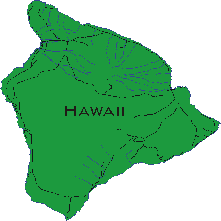
- Enjoy over 440 Megabytes of Digital Line Graphs and Digital
Raster Graphs for the Grand Canyon, Rocky Mountain, and Yellowstone National Parks
included on the CD.
On-screen Digitizing
With Didger you can perform on-screen digitizing using an
imported bitmap or an image you scanned using Didger’s scanning functionality.
Performing "Heads-Up" digitizing has never been easier. Didger has all the
functionality necessary to geo-reference the bitmap image to a real world coordinate
system using one of four geo-referencing methods. Once the image has been geo-referenced,
Didger allows you to digitize points, polylines, and polygons with ease.
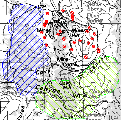
Extract regions and points from a
scanned topo map.
Vector Based Maps and Projections
With Didger you can import a variety of vector based maps
in many formats. Create large coverages easily by importing several vector files. The
files will align according to their coordinate systems, or can even be imported from files
with different projection systems and merged into the projection of the first file using a
datum transformation. Digitize new features onto an existing vector plot from your
digitizing tablet and map, or digitize on-screen. Import USGS SDTS Digital Line Graphs
retaining the projection information. Change line styles, object IDs, and add labels to
objects with ease. Even import different files onto separate layers!
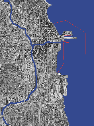
Import USGS SDTS DDF files and retain
projection information or change to a new projection.
Geo-referenced Raster Based Maps
Import your GeoTIFF images directly into Didger 2 and
retain all the geo-referencing parameters. Digitize features from your bitmap and export
them with the image in GeoTiff format. Or, simply export the vector features without the
underlying bitmap and still retain the projection information. Use the numerous filtering
options on the bitmap to make identifying and digitizing the objects a breeze. If your
bitmap doesn’t contain projection information, calibrate the image and export it as a
GeoTiff image. Didger also supports creating ESRI World Files [TFW] when exporting
geo-referenced bitmaps. This is a powerful and advanced feature of Didger!
Import GeoTiff or any raster image, then
digitize features to export with geo-referenced parameters.
Map Projections , Coordinate
Conversions, and Image Calibration
Converting data from one coordinate system to another is
one of Didger's advanced features. With a few simple steps, Didger can transform
your Lat/Long point data into Universal Transverse Mercator (UTM) coordinates to be used
by other mapping applications. Converting coordinates by applying a simple math operation
is easily supported in Didger. This function allows the user to specify a value to add,
subtract, multiply, or divide to the current vector project. Advanced geo-referencing
conversion is also available. By specifying the source and destination coordinates of the
vector project, Didger’s advanced geo-referencing methods allow the user to convert
the current project to the new destination coordinate system. The possibilities are
endless and the flexibility is astounding!
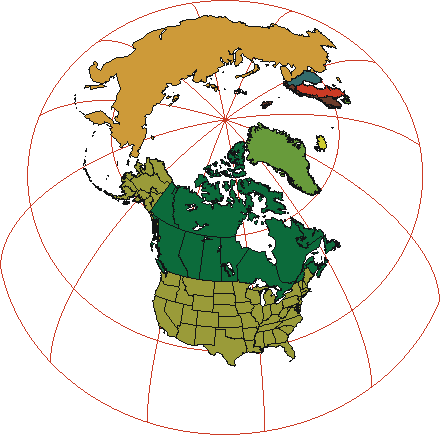
Create stunning world maps in a variety
of projections to convey your information easily.
Advanced Editing Features
- Create line intersections from overlapping polylines.
- Snap Undershoot polylines and trim overshoot polylines.
- Create polygons by using a polygon locator in the center of
linked polyline objects.
- Reshape polylines and polygons.
- Create complex polygons.
- Thin and smooth polylines using one of four different
methods.
- Resample polylines to specified intervals.
- Convert polylines to polygons and vice versa.
- Connect polylines.
Import and Export Formats
Many sophisticated import and export filters come with
Didger, simplifying the transfer of your data and images to and from your other
applications.
- Spatially Referenced formats:
GeoTIFF, TFW, and RSF.
GSB, BNA, DLG, LGO, LGS, DXF, PLT, BLN, CLP, WMF, SHP, MIF,
DDF, E00.
TIF, BMP, TGA, PCX, GIF, WPG, DCX, EPS, JPG, PNG.
- Point Data Import formats:
DAT, CSV, TXT.
DXF, DAT, BLN, BNA, BMP, WMF, EMF, SHP, GIF, CGM, MIF, CLP,
TIF, TGA, PCX, WPG, PNG, JPG, PCT, DCX.
Important News about Digitizing
Tablets
Nearly all digitizing tablets work with Didger. If you
already have a tablet, Didger requires 32-bit WinTab compliant digitizing tablet drivers,
available from most tablet manufactures (for no charge) or from third party vendors. If
you don’t currently own a tablet, you shouldn’t be discouraged. The price of
new, high-resolution digitizing tablets is astonishingly low. And with Didger’s
capabilities, large maps are easily digitized in a single project so even smaller tablets
work quite well.
Want to see a list of tablet manufacturers?
Beta Tester’s Comments
"This may end up being your best product because
of its ability to use scanned images and then scale them for printing."
"I really like the design philosophy used to
create polygons from polyline segments."
"Your mixed mode digitizing is very intuitive and
will be well liked by my students. The change projection feature will be a very useful
addition to my exercises that deal with the fundamentals of projections. I am particularly
happy to see the vast improvement in error detection and correction from Didger 1. It
turned out that the biggest problem I have had with Didger 1 was the very tedious methods
by which one was forced to find small and difficult to detect errors, especially when
building polygons from polylines. It is nice to see the tolerance circles and your new set
of tools including, trimming of overshoots, extension of undershoots and creation of nodes
at intersections are very useful. Imports went smoothly. TIF is sometimes difficult due to
different "flavors" but this import (from an Multispec exported .TIF file)
worked well. I adjusted the contrast and brightness. Next, I registered the image by using
six features (road intersections) that had been located by GPS. The registrations went
smoothly and your available options in the various dialog boxes allowed for great control.
I have used layers in other programs like Mapviewer and AutoCAD. This is extremely useful
and your layer management dialog box works like most others so is not hard to pick
up."
"Nice job, one of the most trouble free
beta-version software packages I have ever tested! Also very substantial new features over
Didger 1. I am impressed!"
"Good stuff here! I'm very impressed with the
capabilities of this release of Didger. I think that with the great depth of functionality
of Didger 2, a large number of new users will find good stuff that that they can put to
good use."
"I am very impressed with the design and
functionality of this product and I know that I’m going to find it very valuable in
my work. I would also like to commend you on the high standard of the documentation. Any
procedural question that I had was clearly explained."
Learn more about Golden
Software Products on this CD!
Home * Surfer
* Grapher * MapViewer
* Didger
Please visit the Golden Software web site
at
http://www.goldensoftware.com!
While visiting the web site, you'll be
able to
buy Didger or download a demo copy!
Copyright 1997 - 2000, Golden Software, Inc. |