|
GeoWorld Articles Quantifying Wildland Fire Risk |
Further Understanding
Spatial Patterns and
Relationships ( |
Feature article for GeoWorld,
December 2005, Vol. 18, No. 12, pgs. 34-37
<Click here>
right-click for a printer-friendly version of this paper (.pdf).
<Click here>
right-click for an follow-on paper, January 09 (.pdf)
Quantifying Wildland Fire Risk
by David Buckley, Joseph Berry, Tom Spencer
and Don Carlton
Fighting wildland fires has become a big business. In five of the
last six years, suppression  costs at the federal level
alone surpassed $1 billion annually. With state and local costs believed to be
more than double that, the bottom line of fighting wildland fire is expensive.
In addition, more funds are allocated for fire prevention and preparedness
planning.
costs at the federal level
alone surpassed $1 billion annually. With state and local costs believed to be
more than double that, the bottom line of fighting wildland fire is expensive.
In addition, more funds are allocated for fire prevention and preparedness
planning.
Because of the significant economic and human impacts of wildland fires, it's important to address how to mitigate their effects. Risk assessment helps fire managers and planners identify the locations of likely impacts and analyze mitigation measures before a catastrophe. Wildland fire risk assessments also serve as a baseline for monitoring change in fire susceptibility and effects.
This article describes a scaleable wildland fire risk-assessment framework that incorporates spatial and temporal factors. The ongoing Southern Wildfire Risk Assessment (SWRA) project serves as a case study.
SWRA Framework
The
The Sanborn wildland fire
risk-assessment approach used an assessment model that incorporates two core
components: the Wildland Fire Susceptibility Index (
The Fire Effects component integrates ratings for values impacted, assets at risk and suppression difficulty to determine an overall rating of effects of a wildland fire. Fire-effects inputs may change substantially based on the geographic area of interest. By combining these two core outputs, a Level of Concern index can be derived.
Framework Scalability
The basic risk-assessment process is the same across geographic and temporal scales. Data are compiled, values are computed, and information is ranked and combined to create final outputs. However, the objective of a wildland fire risk assessment typically impacts the type and resolution of the data required.
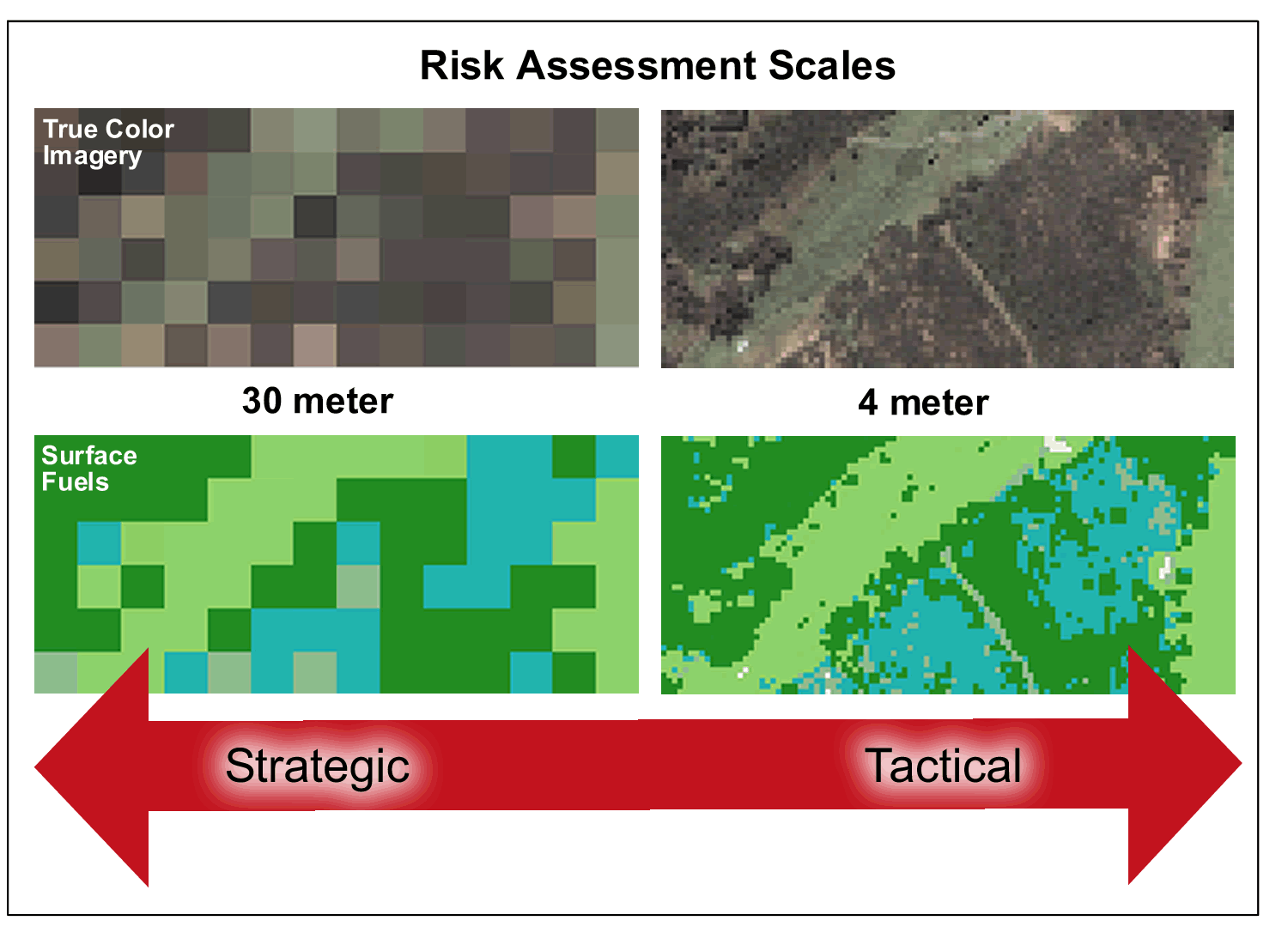
Figure 1. A graphic reflects how spatial resolution (scale) relates to
the utility of fuels data for strategic vs. tactical risk assessments.
The model can be executed at any data scale. However, given the strategic focus of most assessments, a 30-meter grid-cell size is typically used for modeling. This is consistent with readily available remote-sensing data sources, such as Landsat, that provide extensive coverage for typical county/state assessments.
Figure 1 reflects how spatial resolution (scale) relates to the utility of fuels data for strategic versus tactical risk assessments. In general, the finer the spatial resolution, the better the data for detailed community-scale analysis. However, a threshold exists at about four meters, where more detail extends beyond the ability of the fire planner.
Southern Wildfire Risk
Assessment
The project is undertaken by the Southern Group of State Foresters, with state and federal support, including U.S. Department of Agriculture Forest Service Region 8, U.S. Fish & Wildlife Service, Bureau of Indian Affairs, and National Park Service. The Texas Forest Service manages the project, with Sanborn providing the technical development and implementation.
The SWRA project reflects the latest achievements in regional risk assessment and provides a consistent, comparable set of results as a foundation for mitigation planning. When completed in December 2005, SWRA will help the states allocate available resources to meet the needs of the existing wildland fire situation. This will allow each state to prioritize the areas where tactical analyses and community interaction or treatments might be necessary to reduce fuels and risks.
Mapping Fuel Models
Wildland fire risk assessment requires the compilation and development of numerous input datasets. Fuel models often are viewed as the most critical and costly dataset, and thus tend to dictate the design and resolution of the remaining risk-assessment datasets.
Typically, fuels are mapped to match the 1982 Fire Behavior Prediction System fuel models, using 13 fuel models that fall within four basic groups of Grass, Shrub, Timber Litter and Slash. A new 2005 Fuel Model Set extends the model to more than 40 definitions, providing greater detail. However, it awaits evaluation to determine the impact of applying this classification scheme to regional risk assessments.
Remote-sensing approaches are preferred for mapping fuel models, as they tend to provide more accurate fuel maps compared to existing vegetation dataset crosswalks. In addition, they provide a technical baseline for future updating of fuels on a regular basis using cost-effective change-detection methods. To define a level of reliability for fuels data, a quantitative accuracy assessment, utilizing field surveys, is typically undertaken.
For the SWRA project, fuels were derived for the southern states by cross-walking existing data provided by government agencies. This approach provides a cost-effective method for mapping fuels and is sufficient for wildland fire risk assessment. It's anticipated that future procedures will incorporate remote-sensing methods and the new Fuel Model Set to provide more up-to-date data and more fully support management planning activities.
Historical Fire Occurrence
Fire-reporting systems used by states are highly variable and often involve large tracts of land managed by other agencies without common fire-reporting practices and formats. A technical challenge exists to take the discrete point data from disparate data sources, with different geo-referencing units, and derive a uniform continuous map of historical fire occurrence.
A variety of
The result is a map that depicts the probability of a fire igniting in any given grid cell. When combined with fuels, terrain, historical weather, fire behavior, rate of spread vs. final fire size, and other historical data, the probability of any cell burning can be calculated.
|
Key Inputs
Key Outputs |
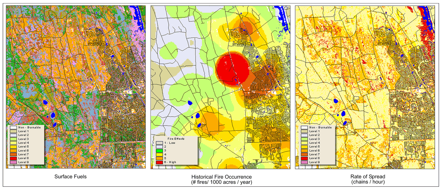
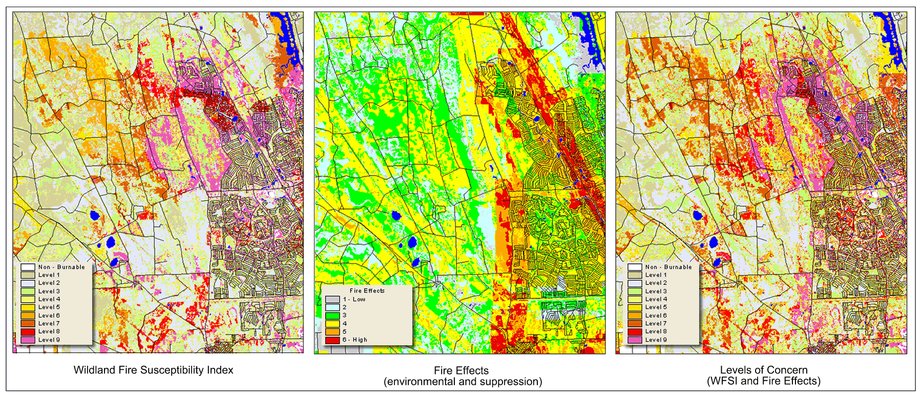
Figure 2. Three maps (top) represent examples of key inputs into the
Wildland Fire
Susceptibility Index model, including fuels,
derived historical fire occurrence and
rate of spread. Another set of maps (bottom)
show key risk-assessment outputs of Wildland Fire Susceptibility Index, Fire
Effects and Levels of Concern.
Figure 2 presents examples of key
inputs into the
Conducting Behavior Analysis
The goal of the risk model is to
generate ranking information that can be combined into a simple set of outputs
for decision makers. The primary output,
The FlamMap fire-behavior program
is commonly used for wildland fire risk assessment. It's
a set of raster prediction models that calculates the behavior of a fire
occurring in each grid cell under specified weather conditions. Fire behavior
is described independently for each individual cell, and the program doesn't
account for processes that might affect fire behavior in adjacent cells.
Unfortunately, FlamMap doesn't
facilitate seamless integration with
Quantifying Fire Probability
The Sanborn wildland fire risk-assessment model is encapsulated into an ArcGIS application, which provides access to final risk-assessment results. However, it also provides capabilities for evaluating areas of interest by enabling users to revise input parameters, modify key input data layers and derive updated risk outputs. Tools also are provided for simulating fuel treatments in areas of interest as well as analyzing the impact over time and, ultimately, on risk levels.
Using the custom ArcGIS application and risk model, a range of outputs is being derived for the SWRA project. Results are being developed on a state-by-state basis, with review and quality assurance currently underway with state representatives.
After results are complete and finalized, they will be provided to state agencies for use in ongoing fire planning. The primary outputs will help states quantify the current situation related to wildland fire risk. This will provide the basis for mitigation planning and continued analysis of prevention options.
Incorporating Fire Effects
Although the
Fire effects are categorized as impacted values ratings and suppression difficulty ratings. Impacted values can include data such as utilities infrastructure, smoke-sensitive areas, plantations, Wildland Urban Interface, etc.
Suppression difficulty ratings define the difficulty of suppression by fuel type and certain land-cover types (i.e., organic soils, etc.) in a fire scenario. Fire planners and project experts participate in workshops to define the fire-effects criteria and values.
This information is integrated into a model that enables fire planners to evaluate fire effects by modifying and weighting the ratings for any given area of interest, reflecting local knowledge. The purpose of the fire-effects index is to identify areas that have environmental values at risk to wildland fire and/or are costly to suppress.
Applying Assessment Results
By combining the probability of any area burning with the expected fire effects, a risk Level of Concern can be defined, which informs where a fire is likely to occur as well as where it will be difficult to suppress and might seriously affect areas of value.
These results can be used in a
variety of ways, including the analysis and planning of mitigation projects as
well as wildland fire-suppression efforts. Figure 2 also illustrates the three
primary outputs from the risk model:
The encapsulation of assessment
results into an Arc-
Tools are provided to support the
analysis of fuel-treatment options where planners can design fuel treatments
and simulate the change in fuels over time based on treatment type and see the
impact that these treatments may have on the risk rating. The
Categorizing Risk for
Communities
A community is considered "at risk" from wildland fire if it lies within the Wildland Urban Interface. Communities need to be categorized to determine their High, Medium or Low risk so that mitigation planning can be prioritized and funding secured through the National Fire Plan and other federal programs.
It's likely that more communities will seek financial assistance for detailed fire planning than can be supported by available resources. The SWRA assessment provides an objective, consistent, comparable and repeatable method for defining risk.
In 2001, a federal register of "communities at risk" identified more than 22,000 communities in the United States that are located within the Wildland Urban Interface. Although this was the first attempt to identify communities at risk, it simply provided a list of community names.
In 2002, the Western Governors Association published a report identifying explicit implementation steps for reducing hazardous fuels and community assistance. More recently, the National Association of State Foresters produced guidelines proposing that communities should be categorized, not ranked, using technical analysis that incorporates the following:
- Risk defined as historic fire occurrence
- Hazards as fuel conditions
- Values to be protected
- Protection capabilities
The SWRA approach integrates the science, data and criteria for identifying and categorizing these communities. The risk-assessment model facilitates the categorization by applying user-defined thresholds, because the analysis will likely vary for different organizations or regions in a county.
|
|
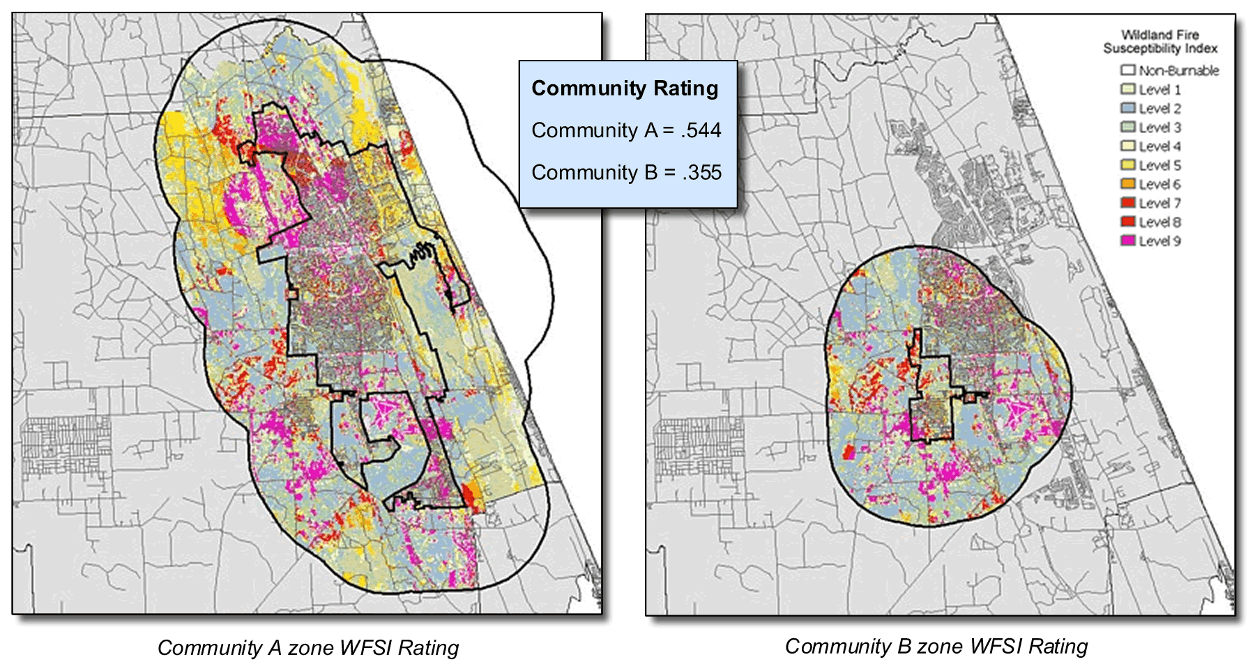
Figure 3. Example community ratings are derived by aggregating wildland
fire risk for Wildland Urban Interface areas.
Figure 3 shows an example of how two communities and their Wildland Urban Interface zones utilize the risk-assessment results to derive a categorical rating of risk for each community.
A general wildland fire risk-assessment framework can be used to do the following:
- Conduct a landscape-scale wildland fire risk assessment
- Categorize communities according to the likelihood that an acre will burn
- Support a community-level assessment and the development of Community Wildfire Protection Plans
Because wildland fire risk assessment is a spatio-temporal phenomenon, it's important to have a process that's flexible and consistent over time and space. Also, it's critical to use proven analytical processes based on accepted science to adequately integrate the inputs to the intermediate and fine measures of potential effects.
The SWRA approach quantifies the wildland fire risk across the South as well as provides the information necessary for identifying communities at risk and mitigation planning. It also raises the bar and provides a glimpse at the future of wildland fire assessment and planning.
_________________________
David Buckley is director,
GIS Solutions, Sanborn Map Company; e-mail: dbuckley@sanborn.com
Joseph Berry is Keck
Scholar in Geosciences at the
Tom Spencer is SWRA
project manager,
Don Carlton is president
of Fire Program Solutions; e-mail: dcarlton1@aol.com.