|
A Consensus Method
Finds Preferred Routing |
Further Reading for Understanding Spatial Patterns and Relationships (Berry, 2007 GeoTec Media) |

Feature article for GeoWorld, April
2004, Vol. 19, No. 3, pgs. 22-25
<Click here> right-click for a
printer-friendly version of this paper (.pdf).
A Consensus Method Finds Preferred Routing
by Jesse Glasgow, Steve French, Paul Zwick, Liz Kramer, Steve
Richardson and Joseph K. Berry
Introduction
Determining the best route through an area is one of the
oldest spatial problems. Meandering animal tracks evolved into a wagon trail
that became a small road and ultimately a superhighway. Although this empirical
metamorphosis has historical precedent, contemporary routing problems involve
resolving complex interactions of engineering, environmental and social
concerns.
Previously, electric transmission line siting required
thousands of hours around paper maps, sketching hundreds of possible paths, and
then assessing feasibility by "eyeballing" the best route. The tools
of the trade were a straightedge and professional experience. This manual
approach capitalizes on expert interpretation and judgment, but it's often
criticized as a closed process that lacks a defendable procedure and fails to
engage the perspectives of external stakeholders in what constitutes a
preferred route.
Selection of preferred routes--and the prerequisite choice
of broad, generalized routing called corridors--is a growing source of public controversy
and regulatory scrutiny throughout the United States. The electric industry has
responded with many initiatives, including a new GIS-based system that could
radically change the way electric utilities evaluate and select transmission
line routes.
The GTC/EPRI
Project
The Electrical Power Research Institute (EPRI) and Georgia
Transmission Corp. (GTC) are developing a prototype GIS tool that integrates
satellite imagery with layers of statewide GIS datasets. In addition, standard
business process and site-selection methods are being created in the hopes of
developing new industry standards. The GTC/EPRI Transmission Line Siting
Methodology Research Project is an example of how geotechnology can be used to
improve productivity and help address a critical industry-wide challenge.
GTC, provider of electric transmission for 39 electric
cooperatives, is sponsoring the EPRI project that's being developed with the
participation of utilities, government agencies, elected officials and
community stakeholders from Georgia and neighboring states. Transmission lines
carry bulk power from generating facilities to local distribution systems that,
in turn, carry electricity to homes and businesses. EPRI is a nonprofit energy
research consortium that provides science- and technology-based solutions for
the world's energy industry.
GIS Needed
Although the exact set of factors to be considered may
change in different parts of the country, most transmission line routing
requires attention to environmental
(e.g., wetlands and flood plains), community
(e.g., existing neighborhoods and historic sites) and engineering (e.g., slope and access) factors.
GISs are explicitly designed to manage and combine large
amounts of spatially distributed data. In fact, transmission line siting can be
thought of as a special case of land suitability analysis that drove much of
GIS' early development.
Authority to use land is critical for electric transmission
lines. GIS siting methodology attempts to use sound science and technology to
expedite approvals, getting projects built on time and at lower costs. The
National Environmental Policy Act (NEPA) and best-management practices require
documentation that constrains project siting. The purpose of documentation
isn't to generate reams of paperwork, but to foster excellent siting decisions.
However, the site selection process can take years and millions of dollars, and
it often disenfranchises affected parties.
The documentation process doesn't mandate a standard
routing procedure or particular substantive results. It does require, however,
a thorough study of consequences of proposed actions. It requires proponents to
look at the effects of alternatives as well as articulate satisfactory
explanations, including rational connections among facts found and choices
made.
Adopting GIS methodology streamlines the decision
documentation process and promotes consistent, quantitative and defensible
"standards" for examining data, articulating explanations and
demonstrating connections among facts and choices. GIS siting procedures help
proactive companies implement strategies that anticipate critical land-use
issues affecting transmission line placement.
Approach Overview
The EPRI Transmission Line Siting Methodology is analogous
to a funnel into which geographic information is input and a preferred route
emerges (see Figure 1). Geographic information is calibrated and analyzed in
phases with increasing resolution. Proceeding down and through the funnel, the
suitability analysis process continuously refines the corridor(s) most suitable
for transmission line construction.
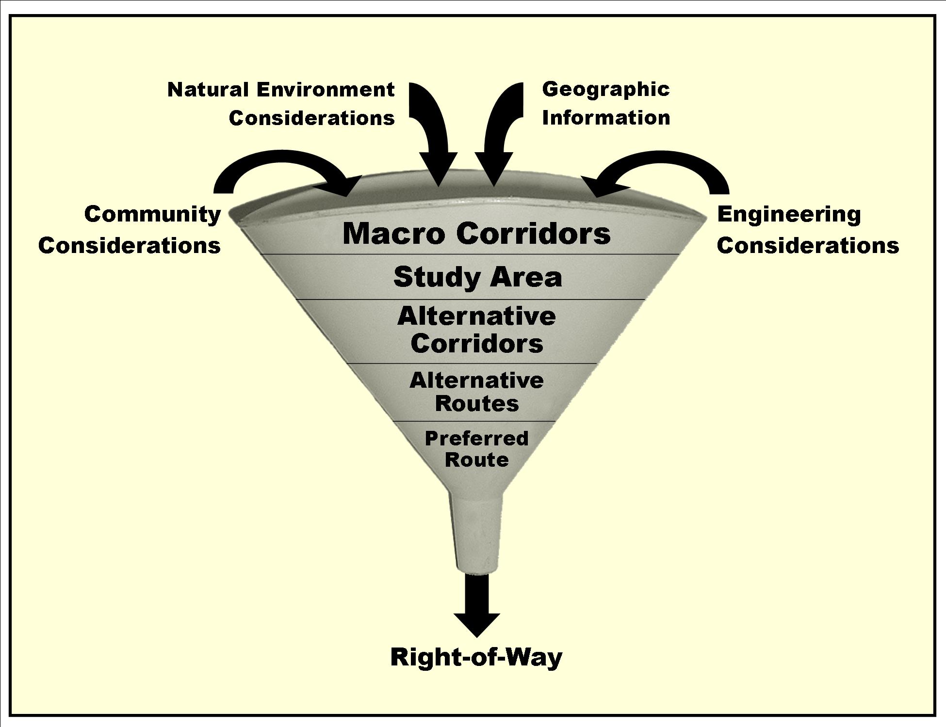
Figure 1. The
route-selection process can be conceptualized as a funnel that successively
refines potential locations for siting a transmission line.
For example, at the macro corridor level, statewide data
based on 30-meter satellite imagery are used to identify the study area,
whereas at the alternate-routes step, four-meter grid cells are used to capture
highly resolved information such as the position of buildings to identify
preferred routes.
Geographic features are organized by scale (resolution) and
discipline. To rank individual features by suitability and weight feature
groups by relative importance, internal and external stakeholder input is
gathered using the "Delphi Process" that builds consensus as well as
the "Analytical Hierarchical Process" (AHP) for pair-wise comparison.
Four separate suitability surfaces are created, placing more decision-making
preference on the following:
1. Optimizing engineering considerations
2. Built environment consequences
3. Natural environment impacts
4. Averages of preference factors
After the four preference surfaces and a map of areas to
avoid (e.g., airports, large water bodies) are available, Photo Science Inc.'s
Corridor Analyst software is used to measure the accumulative preference for
all possible routes connecting the endpoints. The total accumulative preference
surface from the start and endpoints is classified to delineate the top 3
percent of all possible routes. The process results in four alternative
corridors reflecting the routing preferences contained in the suitability
surfaces (see Figure 2).
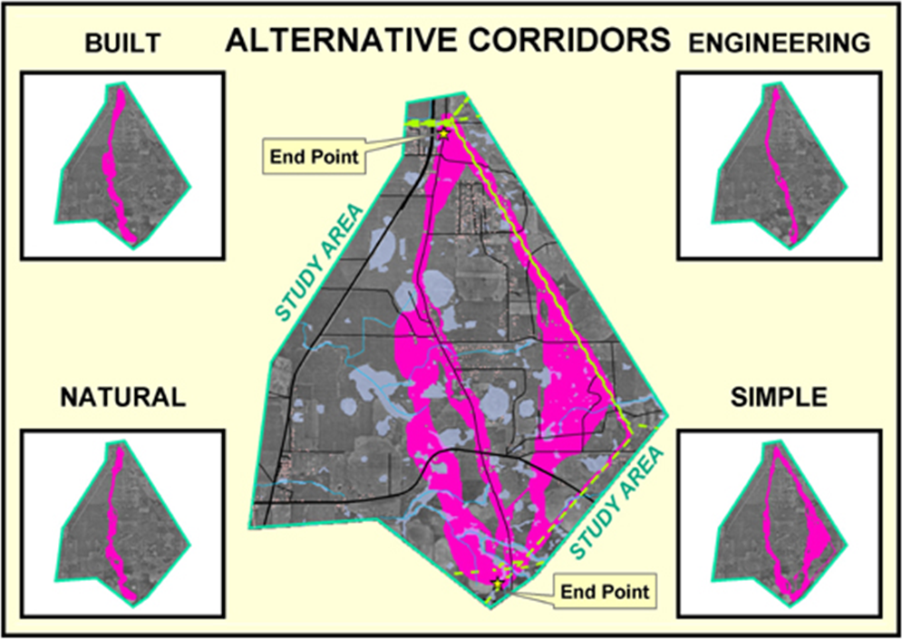
Figure 2. Alternate
routes are generated by evaluating the siting model using weights derived from
different group perspectives.
Adding Data
Within the alternative corridors, additional data are
gathered (e.g., buildings and property lines), and a team of routing experts
define a network of alternative route segments for further evaluation (see
Figure 3). Statistics, such as acreage of wetlands affected, number of streams
crossed, number of houses within close proximity, etc., are automatically
generated for each of the alternate route segments.
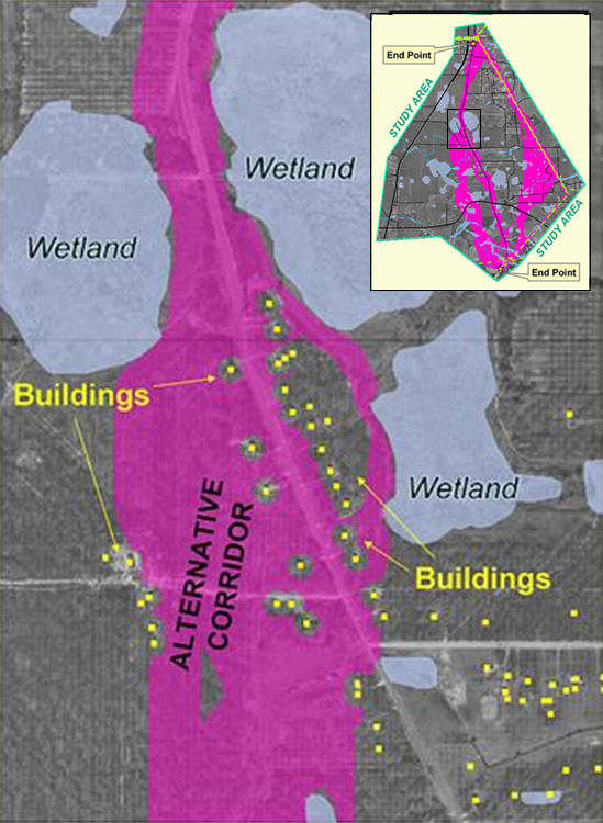
Figure 3. Within
the alternate corridors, additional data are gathered such as exact building
locations from aerial photography.
Segments with connectivity are defined, and segment
statistics are summed to create alternative route statistics. Based on spatial
data and other factors, the siting team uses AHP pair-wise comparison to assign
weights to the alternative routes, resulting in a relative ranking of each
route alternative. The highest-ranking route identifies the preferred route
corridor (see Figure 4).
Detailed field surveys are conducted along the preferred
route (collecting data using Global Positioning System, photogrammetry, light
detection and ranging, and conventional surveying techniques) to map cultural,
ecological, topographical and physical features. Engineers make slight
centerline realignments and then design the final pole placements and
construction estimates based on the information.
Input for determining the calibration and weighting of
routing criteria was gathered from subsets of the stakeholders appropriate for
the group's focus, whether engineering, natural environment or built
environment.
Preference values were assigned based on a standardized
process predefined by the model-development team. For each of the engineering
layers (slope, linear features and selected land uses), individual stakeholders
valued each feature (from 1 to 9) for a range of opportunities. The value 1
indicated the most-preferred feature in the map layer, while 9 was assigned to
the least preferred. For example, 0-15 percent slopes identified the best
conditions, 15-30 percent was moderate, and greater than 30 percent identified
the worst conditions.
A modified Delphi Process was used to gain consensus for
preference values. The values assigned by group participants to each category
were averaged, and the standard deviation was calculated. If the deviation of
the individual preference values for a particular feature was small, the group
agreed that there was consensus and assigned the average preference value for
the feature. If the deviation for a feature was large, the group proceeded to
discuss the range of values and developed consensus through a sequence of
re-evaluations.
Engineering
Considerations
Those participating in the engineering analysis included
engineers and scientists from utilities and state infrastructure agencies
involved with site selection for transmission lines. The group was selected to
provide specific knowledge regarding the collocation of power lines with other
linear features, including transmission lines, roadways, railroads and other
utilities.
After all the layer features had been evaluated, the
selected preference values for all features were used to create a raster
surface of preferences for the individual engineering layers. The AHP process
was used to weight the map layers to reflect relative importance, and a
weighted average was calculated to derive the overall engineering preference
surface. This procedure for calibrating and weighting map criteria also was
used for assessing the project effect on the natural and built environment
perspectives.
Natural Environment
Numerous federal and state laws such as the Endangered
Species Act, the Clean Water Act, National Pollution Discharge Elimination
System, and wetlands and riparian buffer regulations drive the selection of
environmental criteria. Many of the rules require obtaining permits from
regulatory agencies and often require mitigation of impacts. Additional
environmental criteria have been established as part of GTC's business
policies, such as avoiding lands with private conservation easements as well as
state and federally owned lands.
The natural environment stakeholder group included members
of the regulator community such as the U.S. Army Corps of Engineers, U.S.
Environmental Protection Division and Georgia Department of Natural Resources
as well as local representatives from non-government organizations in the
environmental community.
For the most part, the group reached consensus for factors
that had good regulatory foundations. For criteria without regulatory rules,
such as public-land issues and other land-use categories, it was more difficult
to reach group agreement. A few of the factors initially considered by the
environmental group, such as intensive agriculture and small water-retention
ponds, turned out to be better considered by the engineering or built groups.
Built Environment
NEPA and various state-level policies require consideration
of aspects of the built environment, such as historic sites. However, the most
important obstacle to siting new transmission lines has been opposition from
homeowner and community groups. An effective transmission line siting method
can't be blind to community and neighborhood preferences.
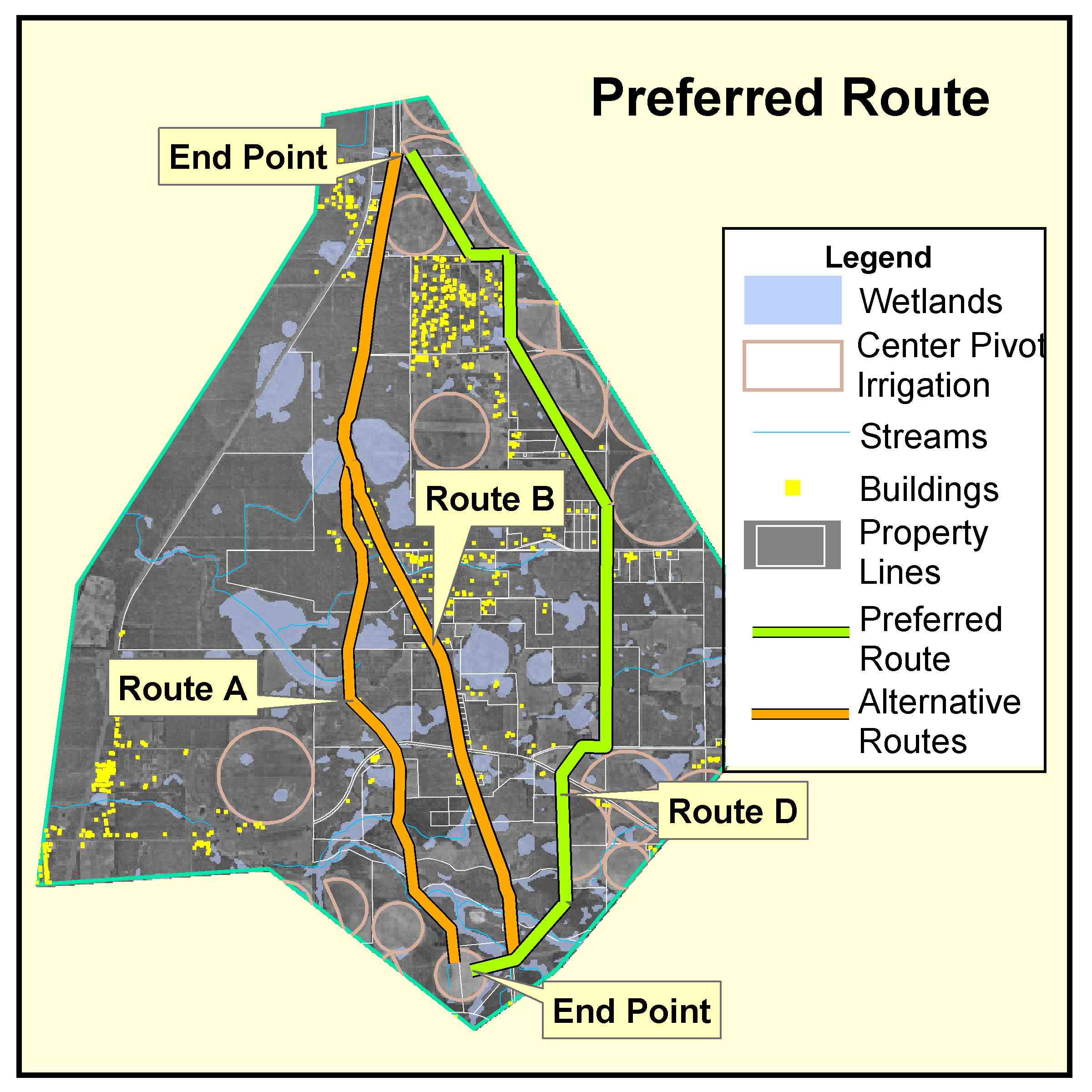
Figure 4. A
GIS-generated preferred route is adjusted as necessary based on detailed field
information and site-specific construction requirements.
The built environment stakeholder group provided input on
community concerns for appropriate calibration and weighting of preference
surfaces. The group included professionals in historic planning, regional
planning, community development and local government as well as representatives
from homeowner and neighborhood organizations. The stakeholders first
calibrated the scale for each measure and then determined the importance
weighting for the following built environment layers: proximity to buildings,
proximity to cultural resources, building density, proximity to proposed
development, visual vulnerability and proximity to excluded areas.
Actual buildings were handled as avoidance areas, and a
fairly high level of consensus was reached. The same process was conducted with
a group of utility professionals, and similar results were achieved.
Lessons Learned
In January 2004, a workshop was held with transmission line
siting professionals from 10 utility companies. The professionals were asked to
review and comment on the methodology described in this article. The GTC/EPRI
methodology is generally similar to the processes that other utilities currently
are using. All were using some type of GIS-based system, and most used a
process that focused on more-detailed data as siting alternatives were
narrowed.
Most utility representatives thought that this new
methodology was more organized, comprehensive and consistent than their current
practice, and most thought the methodology would produce consistent routing
based on sound and documented science. Particular interest was expressed in the
efficiency of the macro corridor analysis technique to guide the collection of
successively more-detailed data.
Probably the most important difference among utilities was
in how they handled public involvement. Some utilities ask stakeholders to
identify criteria and weight them for each project; others develop alternative
routes and ask stakeholders to select from that set; still others rely on an
internal siting team with little involvement from the public.
Our experience found that asking citizen stakeholders to
work directly with weights and criteria among group perspectives didn't produce
a viable model. Citizens tried to "game the system" in setting
weights to favor their perspective, often producing unintended results. Our
final approach combines the criteria and weights identified by citizen
stakeholders with those identified by professionals. This process incorporates
public opinion and professional experience to create a consistent model that
can be used on a range of projects.
In addition, we found that stakeholders often confused
proximity measures with the feature itself. When stakeholders set large
proximity zones around features they considered valuable, they would
inadvertently force the route into other valuable areas. We also found that it
was important to include data about land use in the model.
In an effort to reduce cost, the research team initially
considered all buildings the same regardless of use. It became evident that
it's necessary to have the model distinguish among residential, commercial and
industrial buildings. Most stakeholders considered residential buildings more
sensitive than commercial and industrial structures, and the model needed to be
able to resolve at least this crude level of land-use distinction.
GTC intends to apply the methodology for all future
transmission projects. The structure and rigorous procedure is no substitute
for the judgment, values or perspectives of the stakeholders, and it
depends--more than ever--on the skill and experience of the professional staff
involved.
The GTC/EPRI routing methodology provides a structure for
infusing diverse perspectives into siting electric transmission lines.
Traditional techniques rely on expertise and judgment that often seems to
"mystify" the process by not clearly identifying the criteria used or
how it was evaluated.
The GIS-based GTC/EPRI approach is an objective, consistent
and comprehensive process that encourages multiple perspectives for generating
alternative routes, and it thoroughly documents the decision process. The
general approach is readily applicable to other siting applications of linear
features such as pipelines and roads.
_________________________
Authors' Note: For
more information on routing and optimal path procedures, visit the Web at http://www.innovativegis.com/basis/MapAnalysis, select
Topic 19, Routing and Optimal Paths. Links to further discussion of Delphi and
AHP in calibrating and weighting GIS model criteria are included.
______________________________
Glasgow is Georgia Transmission Corp. operations
manager, Photo Science Inc.; e-mail: jglasgow@photoscience.com
French is director, Georgia Tech Center for GIS;
e-mail: steve.french@arch.gatech.edu
Zwick is chair, Department of Urban and
Regional Planning, University of Florida; e-mail: paul@geoplan.ufl.edu
Kramer is a research scientist, Institute of
Ecology, University of Georgia; e-mail: lkramer@arches.uga.edu
Richardson is a member, Van Ness Feldman, Attorneys
at Law; e-mail: rsr@vnf.com
Berry is the Keck Scholar in Geosciences,
University of Denver; e-mail: jkberry@du.edu