Site-Specific Farming Comes of Age: Managing Field
Variability
California FarmTech
Conference – Santa Barbara, California – January 26-27, 1998
Presentation by
Joseph K. Berry
(Article for FarmTech online communication, Rincon
Publishing, Carpinteria, California, January, 1998. For more information on
related activities access http:/www.rinconpublishing.com/farmtech.html on the
worldwide web)
<click here> for a printer-friendly version (.pdf)
…the farm community doesn’t want to be entrapped by a new
technology; it wants to be empowered by useful new tools—
Site-specific management, often referred to as "precision
farming," means different things to different people— from the
pinnacle of farm efficiency, to a vast array of new products and services, to
the techno-death-throws of indigenous insight and quite possibly, farming as we
know it. In reality, it is likely none of the wealth of individual
perspectives, but an amalgamation of them all. All parties, however, appear to
agree that this emerging technology is intimidating, confusing, and often
misunderstood. This presentation attempts to remove some of the mysteries and
misconceptions by outlining the elements of site-specific management, the
technical issues surrounding its development, the legal issues and their impacts,
and important extended issues and trends driving site-specific management. But
first a brief discussion of what site-specific management is (and isn’t)
is in order.
What
Site-specific Management Is (and Isn’t)
In essence, site-specific management is about doing the right thing,
in the right way, at the right place and time. It involves assessing and
reacting to field variability and tailoring management actions, such as
fertilization levels, seeding rates and variety selection, to match changing field
conditions. It assumes that managing field variability leads to both cost
savings and production increases. Site-specific management isn’t just a
bunch of pretty maps, but a set of new procedures that link mapped variables to
appropriate management actions. This conceptual linkage between crop
productivity and field conditions requires the technical integration of several
elements.
Elements of
Site-Specific Management
Site-specific management consists of four basic elements: global
positioning system (GPS), data collection devices, geographic information
systems (GIS) and intelligent implements. Modern GPS receivers are able
to establish positions within a field to about a meter. When attached to a
harvester and connected to a data collection device, such as a
yield/moisture meter, these data can be "stamped" with geographic
coordinates. A GIS is used to map the yield data so a farmer can see the
variations in productivity throughout a field.
The GIS also can be used to extend map visualization of yield to
"map-ematical" analysis of the relationships among yield variability
and field conditions. Once established these relationships can be used to
derive a "prescription" map of management actions required for each
location in a field. The final element, intelligent implements, reads
the prescription map as a tractor moves through a field and varies the
application rate of field inputs in accordance with the precise instructions
for each location. The combining of GPS, GIS and IDI (intelligent devices and
implements) provides a foothold for both the understanding and the management
of field variability.
Smart
Farmers, Dumb Maps
To date, most analysis of yield maps have been visual interpretations. By
viewing a map, all sorts of potential relationships between yield variability
and field conditions spring to mind. These visceral visions and
explanations can be drawn through the farmer’s knowledge of the
field— "I bet this area of low yield aligns with that slight
depression," or "maybe that’s where all those weeds were,"
or "wasn’t that where the seeder broke down last spring?" Data
visualization can be extended through GIS analysis directly linking yield to
field conditions.
This map-ematical processing involves three levels: cognitive,
analysis and synthesis. At the cognitive level (termed desktop mapping)
computer maps of variables, such as crop yield and soil nutrients, are
generated. These graphical descriptions form the foundation of site-specific
management. The analysis level uses the GIS’s analytical toolbox
to discover relationships among the mapped variables. This step is analogous to
a farmer’s visceral visions of relationships, but uses the computer to
establish mathematical and statistical connections. To many farmers this step
is an uncomfortable "leap of scientific faith" from pretty maps to
pure, dense techy-gibberish. However, map-ematical analysis greatly extends
data visualization and can more precisely identify areas of statistically high
yield and correlate them to a complex array of mapped field conditions.
The synthesis level of processing uses spatial modeling to
translate the newly discovered relationships into management actions
(prescriptions). The result is the prescription map needed by intelligent
implements in guiding variable rate control of field inputs. Admittedly, the
juvenile science of site-specific management is a bit imprecise, and raises
several technical issues.
Technical
Issues
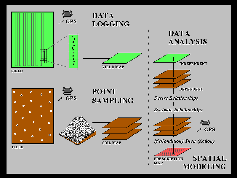 The accompanying figure identifies the four basic
processing steps in site-specific management. Data collection for site-specific
management can be divided into two broad areas: continuous data logging and
discrete point sampling. Data logging continuously records measurements,
such as crop yield, as a tractor moves through a field. Point sampling,
on the other hand, uses a set of dispersed samples to characterize field
conditions, such as phosphorous levels.
The accompanying figure identifies the four basic
processing steps in site-specific management. Data collection for site-specific
management can be divided into two broad areas: continuous data logging and
discrete point sampling. Data logging continuously records measurements,
such as crop yield, as a tractor moves through a field. Point sampling,
on the other hand, uses a set of dispersed samples to characterize field
conditions, such as phosphorous levels.
The nature of the data derived by the two approaches are radically
different— a "direct census" of yield versus a
"statistical estimate" of phosphorous. In data logging, issues of
accurate measurement, such as GPS positioning and material flow adjustments,
are major concerns.
In point sampling, issues of spatial interpolation (estimating between
sample points), such as sampling frequency/pattern and interpolation technique,
are the focus of concern. In both cases, the resolution of the analysis grid
used to geographically summarize the data is a critical concern. If the
analysis grid is too coarse, information is lost in the aggregation over large
grid spaces; if too small, measurement and positioning errors are influential.
The technical issues surrounding mapped data analysis and spatial
modeling involve the validity of applying traditional statistical
techniques to spatial data. For example, regression analysis of field plot data
has been used for years to derive crop production functions, such as the corn
yield versus potassium curves you might recall from college. In a GIS, you can
regress a entire map of corn yield on a map of potassium (they’re just
spatially organized sets of numbers) to derive the production curve relating
the two mapped variables— but should you? Technical concerns, such as
variable independence and autocorrelation, have yet to be thoroughly addressed.
Statistical measures assessing results of the analysis, such as a spatially
responsive correlation coefficient, await discovery and acceptance by the
statistical community.
Spatial modeling uses the relationships established during the data
analysis phase to determine the "optimal" actions, such as amount of
phosphorous to be applied to each location in the field. The issues surrounding
spatial modeling are similar to data analysis and involve the validity of using
traditional "goal seeking" techniques, such as linear programming or
genetic modeling, to generate maps of the optimal actions (prescription maps).
At present, the full map-ematically
based approach to site-specific management is in the hands of the researchers.
Like the "chicken or the egg" dilemma, the skeleton of the
site-specific management process is being put in place by a variety of vendors,
thus enabling researchers to continuously refine the analytical/modeling meat.
Putting aside the considerable technical challenges, what are the major social
implications of site-specific management?
Legal
Issues and Impacts
Four important social issues surround site-specific management: intellectual
property rights, intellectual property wrongs, who owns the data, and data
haunting. From the vendor’s point of view intellectual property rights
are a major concern. The issuance of broad patents to individual companies,
such as linking GPS to GIS and variable rate control, reward innovative
thinking, yet generate market uncertainty and stifle open development of an
emerging technology.
Intellectual property wrongs refer to the validity of site-specific management
systems. They all generate pretty maps, but whose map is best? And what
recourse do you have if you follow a bum prescription map and lose the farm?
The need for standards in site-specific management reach far beyond the
developer’s concern for compatible wiring harnesses and data exchange, to
end user needs for assessing system performance and results.
Who owns the data
derived through site-specific management is another important issue. If a
farmer pays for the collection, analysis and synthesis of site-specific
management data about his farm, who owns, and possibly even more importantly,
controls access to these data? Can the analyst use or sell the information
without the farmer’s consent? Or, as with data haunting, can the
data be used in court against the farmer— sort of a high-tech
self-incrimination? As with any new technology, site-specific management is
pushing at the envelope of our traditional social beliefs and legal doctrine.
Extended
Issues and Trends
Site-specific management is pushing, as well, at current definitions of
agricultural research and markets. Historically, agricultural research
involved controlled studies on a few plots in a couple of fields at a
university or experiment station hundreds miles away, involving different
soils, climatic conditions and plant varieties. The data was analyzed and the
findings published. With the advent of site-specific management, a farmer has
access to thousands of "plots" in his own backyard (the analysis grid
used in establishing yield and field condition maps). What is needed is a
switch in emphasis from publishing research findings to transferring research
methodologies so farmers can apply them to their own extensive data sets.
Changes in the agriculture market place and the private/public
sector’s use of GPS/GIS are just as dramatic. A clamor for digital
mapped data is causing mapping agencies, such as the USGS and the NRCS, to
change data collection, map preparation and distribution procedures.
Downloading map digital products over the Internet is already a reality, such
as maps from the National Wetlands Inventory. A booming cottage industry has
sprung up for developing the data bases needed in site-specific management,
such as soil nutrient maps. A growing array of options for the tractor, such as
GPS and notebook computers mounted in the cab, are rapidly appearing. The
proliferation of hardware and software has resulted in a desperate need for standards—
hardware and data exchange standards are obvious, but data processing standards
addressing data errors, conditioning and analysis verge on proprietary
"secrete formulas."
However, data processing is what makes radically different maps, and they
both can’t be right. Without techniques for empirical verification GIS
mapping is "like buying a pig in a poke." Consulting services
specializing in the analysis of site-specific management data are forming. To
date, however, the justification of all this excitement has been on cost
efficiency and crop productivity. However, the natural resources experience
with spatial technologies is much longer and has evolved into a different set
of applications. In the beginning, forestry had an operations-centric view
similar to the current site-specific management one (in many respects, trees
are just 120-foot corn stalks that are harvested every 60 years or so).
GIS’s automation of mapping and inventory activities promised great
savings, and many systems were justified through cost/benefit analysis of
operational efficiency. However, the view of GIS as a "tool"
expediting traditional management procedures quickly evolved into a different
perspective as a radically new "technology" providing entirely new
approaches to resource management.
Foresters became familiar with such foreign concepts as optimal path
analysis and visual exposure density surfaces, and began applying these tools
in innovative ways. More recently, the value of GIS is viewed as not only
making more efficient and well-informed management decisions, but as a
"revolution" in the decision-making process itself. With the advent
of the environmental movement, a forester (vis. farmer) can’t harvest a
single timber stand (vis. crop) without a thorough analysis of its
environmental impacts, such as sediment loading to streams and the
health/welfare of wildlife in the area. From this perspective, spatial analysis
moves from a cost/productivity focus to a required "license to do
business," and bazaar maps, such as the "propensity for
litigation," are now as important as timber inventory maps. It’s
greatest return is as a communication tool in substantiating good stewardship
of the land. As increasing environmental regulations loom in agriculture, such
as the T-factor in soil loss and nitrogen allocations by watershed, the spatial
technologies in site-specific management might become as much a necessity as a
tractor— it already has for your backwoods cousins.
Conclusions
and Some Good Advice
Site-specific management extends our traditional understanding of farm
fields from "where is what" to analytical renderings of "so
what" by relating variations in crop yield to field conditions, such as
soil nutrient levels, available moisture and other driving variables. Once
these relationships are established, they can be used to insure the right thing
is done, in the right way, at the right place and time. Common sense leads us
to believe the efficiencies in managing field variability outweigh the costs of
the new technology. However, the enthusiasm for site-specific management must
be dampened by reality consisting of at least two parts: empirical verification
and personal comfort. To date, there have not been definitive studies that
economically justify site-specific management. In addition, the technological capabilities
(cart) appear to be ahead of scientific understanding (horse) and a great deal
of "spatial research" lies ahead. That brings us to personal comfort.
If you are skeptical of site-specific management and/or feel
"cyber-challenged," you should wait to fully adopt the technology.
However, keep in mind that if site-specific management proves to be more than a
passing fad, its most important ingredient is a robust database — each
year that data collection is postponed it puts a farmer farther behind. In the
information age, a farmer’s ability to react to the inherent variability
within a field might determine survival and growth of tomorrow’s farms.
 Joseph K. Berry (jberry@innovativegis.com) is a
leading consultant and educator in the application of Geographic Information
Systems (GIS) technology. He has written over two hundred papers, several books
and presented hundreds of workshops on the subject. He is a contributing editor
and author of the "Beyond Mapping" column for GIS World magazine and
the "Inside the GIS Toolbox" column for Successful Farming’s
ag/INNOVATOR newsletter. Dr. Berry is the president of Berry and Associates //
Spatial Information Systems, consultants and software developers in GIS
technology. Also, he is a Special Faculty member at Colorado State University,
and the author of the Tutorial Map Analysis Package (tMAP) used by universities
worldwide for instruction in map analysis principles. Formerly, he was the
president of Spatial Information Analysis Corporation and an Associate
Professor and the Associate Dean at Yale University's Graduate School of
Forestry and Environmental Studies. He holds a bachelor's degree in forestry, a
master's degree in business administration and a doctorate emphasizing remote
sensing and land use planning. …for more information see www.innovativegis.com/basis
Joseph K. Berry (jberry@innovativegis.com) is a
leading consultant and educator in the application of Geographic Information
Systems (GIS) technology. He has written over two hundred papers, several books
and presented hundreds of workshops on the subject. He is a contributing editor
and author of the "Beyond Mapping" column for GIS World magazine and
the "Inside the GIS Toolbox" column for Successful Farming’s
ag/INNOVATOR newsletter. Dr. Berry is the president of Berry and Associates //
Spatial Information Systems, consultants and software developers in GIS
technology. Also, he is a Special Faculty member at Colorado State University,
and the author of the Tutorial Map Analysis Package (tMAP) used by universities
worldwide for instruction in map analysis principles. Formerly, he was the
president of Spatial Information Analysis Corporation and an Associate
Professor and the Associate Dean at Yale University's Graduate School of
Forestry and Environmental Studies. He holds a bachelor's degree in forestry, a
master's degree in business administration and a doctorate emphasizing remote
sensing and land use planning. …for more information see www.innovativegis.com/basis
Berry & Associates // Spatial
Information Systems, Inc.