What's New in Didger 3?


What major new features are included in Didger 3?

We have compiled a list of the top new features in Didger 3. This list is only a small sampling of the new features added to Didger 3.


Import Georeferenced Bitmaps into Vector Projects

Didger 3 makes it even easier to display all your data. Import a georeferenced bitmap into a vector project, and overlay it with vector and data files, or tile it with other georeferenced bitmaps!

This map shows two georeferenced bitmaps overlaid with a vector file showing state outlines and a data file showing some of the major cities.


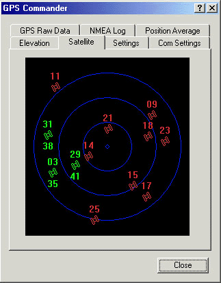
GPS Digitizing

Use your GPS directly with Didger 3! Enable the GPS to plot data directly on a map in Didger or save the GPS data to a text file. View the GPS settings in the GPS Commander dialog box.

View your current elevation, see the current position of the satellites that are being used for a lock, display the raw data being sent from the GPS, and set the GPS input datum in the GPS Commander dialog box.


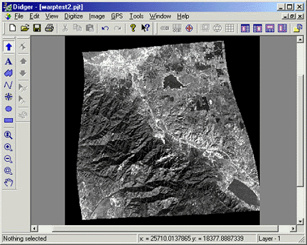
Image Warping

Warp or rectify a bitmap in a raster project! Calibrate the image in a raster project, then use the Warp Image command to rectify the image to match the calibration points.

Warp your image to fit any calibration. Image warping (also called rubber sheeting) is an important feature in Didger 3. Image warping can correct map or image distortion.


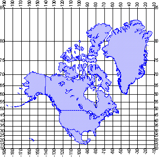
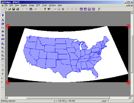
Add a Graticule or Grid

Make the locations of your maps easy to determine by adding a graticule or grid to your vector project. The map below shows North America in the Mercator projection.

Add a graticule or grid to your vector project.


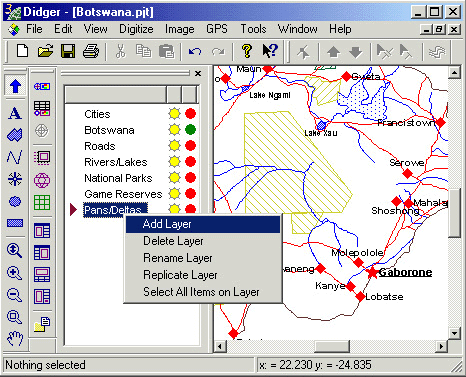
Enhanced Layer Manager

Increase the organizational potential for creating and maintaining different layers with the enhanced Layer Manager. The Layer Manager is "always on" to make accessing the layers simple.


Having the Layer Manager on the side of the Didger window makes accessing the layers simple and easy.


Coordinate Manager

Display all the coordinates of a selected object in a raster project in the Coordinate Manager. If you are in a vector project, you can also edit the coordinates within the Coordinate Manager.

Edit the coordinates of selected objects in a vector project using the Coordinate Manager.


Convert the Projection of Your Bitmaps

Didger 3 allows you to convert the projection of a bitmap in a raster project.

Import a bitmap into a raster project, calibrate it, and then convert the projection into any of the 23 supported projections. The map above was calibrated in Unprojected Lat/Long and then converted to the Albers Equal Area Conic projection.


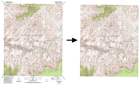
New Bitmap Clipping Options

Bitmap clipping greatly enhances the ease-of-use when working with bitmaps. Two new bitmap clipping options are introduced in Didger 3.

USGS DRG files often have map collars, which contain information about the bitmap. When two or more of these bitmaps are imported into a vector project, it may be undesirable to see this information. Simply select the bitmap and clip the map collar.

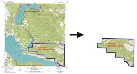
Clip the area outside of the main map on a bitmap in a vector project.

You can also define any polygon on a bitmap and then use that polygon to clip the bitmap. This is helpful in showing specific areas of interest and reducing the file size of the Didger project.


Define a polygon on any bitmap and use it to clip the bitmap.


New Import/Export Formats

Didger 3 has added some new import/export formats to the already extensive selection of import/export formats available:

Vector File Import formats: Golden Software Interchange (*.gsi), and Windows Metafile (Enhanced) (*.emf)

Raster File Import format: Portable Network Graphics Bitmap (*.png)

Data File Import formats: Excel Spreadsheet (*.xls), Microsoft SYLK (*.slk), Lotus 1-2-3 and Symphony (*.w??), Atlas Boundary (*.bna), and Golden Software Blanking (*.bln)

Export format: LAS format, Golden Software Interchange (*.gsi)


Additional New Features

  • Export bitmaps from vector projects when using the Create Surfer Base Map command.
  • Export a project in any of fourteen coordinate units!
  • Use the "And/Or" functionality with Criteria Select.
  • Use the new Create Post Map option when importing a data file.
  • Select up to 256 colors to specify as transparent for a bitmap.
  • Use the new Pan tool to move the plot around in the plot window.
  • Use the new Zoom Realtime tool to zoom in and out.
  • Create one polygon from multiple selected polygons.
  • Use one of the two new projections added to the projection library.
  • Define the datum for the UTM projection.
  • Use the Golden Software on the Web command to connect to the Golden Software web site, go to the Didger web page, or check the Didger FAQs.
  • Use the Check for Update command to check for product updates.
  • Use the Feedback command to report problems, send suggestions, or request information from Golden Software.

Beta Tester’s Comments

  • "I do aerial photography and I am enthralled by the warping/rectification abilities of Didger. That is a very useful tool that I will make good use of. To me, that alone is worth the price of the package."
  • "Digitizing directly from real-time GPS data is a great new feature among an impressive list of Didger 3 capabilities."
  • "The Coordinate Manager will be extremely useful for correcting tablet-based features for which real world coordinates are actually known. I will use it often!! "
  • "I really like the ability to convert the projection or a raster project and the ability to choose a UTM datum when projecting a file."
  • "The Layer Manager is the great tool in Didger, and now it is even easier to work with."
  • "I will definitely use the Graticule and Grid feature. I usually use State Plane coordinates and this allows me to identify the 10,000 ft grid lines I normally use."
  • "Didger has to be one of the most user-friendly programs I've ever dealt with. It's ease of use for digitizing over ArcView or AutoCAD is phenomenal!"

Learn more about Golden Software Products on this CD!
Home  *  Surfer   *  Grapher  *  MapViewer   *  Didger


Please visit the Golden Software web site at
http://www.goldensoftware.com!

While visiting the web site, you'll be able to
buy Didger or download a demo copy!